So on another casual weekend in Wollongong, Lauren and I decided to hop a plane and head to the heart of the country. Australia is he most arid inhabited continent on earth (Antarctica is drier), and Wollongong gets more rain than 80% of the country's land area. Cairns is even wetter, and other than that I haven't been far out of Wollongong, and certainly not off the coast. So it's been a kind of skewed view of the country.
 |
| Picture from the plane of flat and red |
So Lauren and I took a very early train (after getting very little sleep) to the the airport in Sydney, where we flew to the Ayers Rock/Uluru airport. We managed to sleep some on the way, and when we opened the window before landing we were able to look out at an utterly cloudless sky and an utterly flat red landscape. Though given the redness, it was pretty darn green, with way more vegetation than we'd expected to see in the middle of the country, the south of the Northern Territory, the heart of the outback. Turns out that we were exceptionally lucky, arriving during the wettest year in a very, very long time, so everything was blooming, and in unseasonably cool temperatures, so it was eighty instead of over one hundred degrees. It was also not during the major tourist season, so there were really very few people around.

The flight attendant informed us that we had landed on an unusually short runway well ahead of schedule because red planes fly faster, and then told us that the time difference was an hour and a half from Sydney time. A time difference of an hour and a half just seems bizarre. Then again, the Northern Territory seems a little bizarre. It's not actually an Australian state, it's a territory. In 1998 the Australian legislature offered to make it Australia's seventh state, but the majority of voters wanted to keep it as a territory (though opinion poles strongly indicated otherwise). As it stands, the Northern Territory sends representatives to parliament, but they have no power. And all Australian citizens are required to vote, but votes from the Northern Territory apparently don't count. And yet they turned down statehood. Go figure.

But state or not, the Northern Territory is definitely big, flat, red, normally very dry, and normally very hot. We never saw a single cloud while we were there, but the desert was in bloom, and the temperatures were perfect. We were definitely meant to be there. We picked up a rental car and drove ten minutes or so to the little town of Yulara, which consists of a single loop road. We checked in to our campsite, where we were staying in a permanent platform tent, complete with beds, and the bathrooms had soap. This was comfort camping for sure.
We then had the happy realization that, beyond coming to Uluru, we had no plans whatsoever. We drove to a little grocery store and bought some food for breakfast for the next day and discovered a large stock of thirty-nine-cent kiwis (Australians like to price things in single cent increments even though their smallest value coin is a five-cent piece), and bought more than a few to keep us going. Then we went to the little visitor's center and got a brochure showing us the hikes in the park.

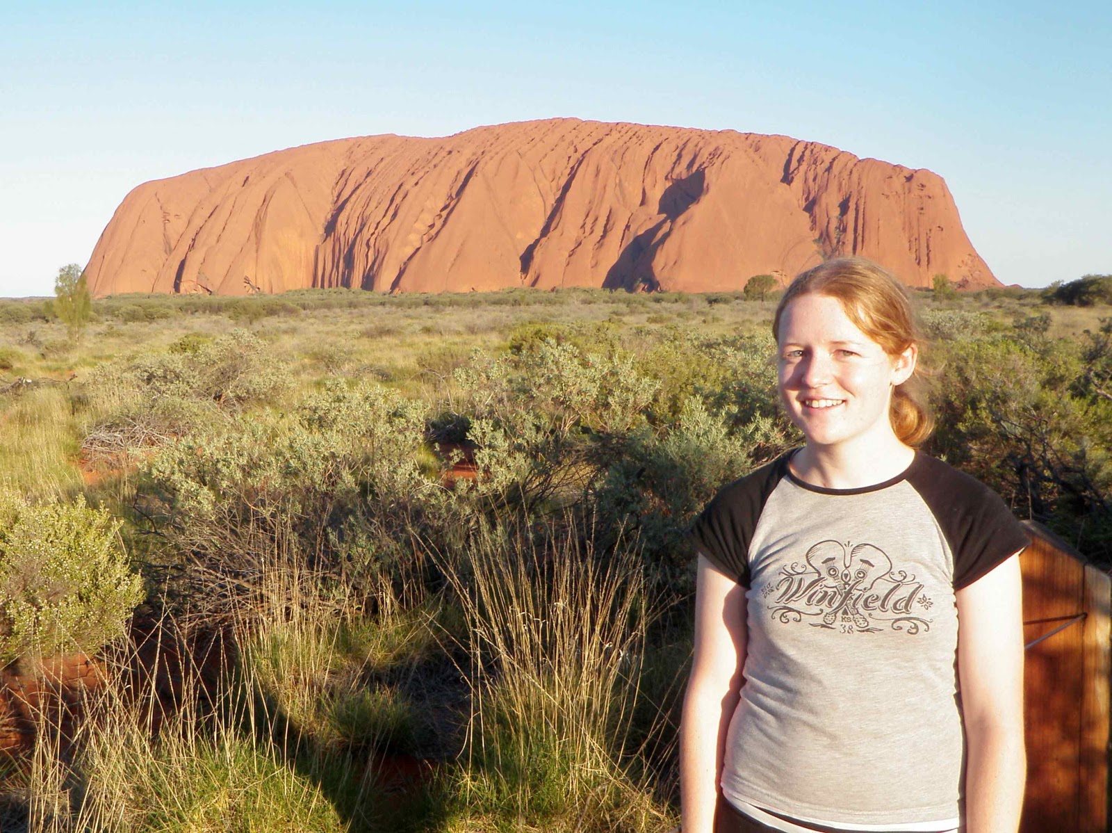
Of course we were there to see the Uluru/Kata Tjuta National Park, and it was only about two in the afternoon thanks to the time change, so we drove about twenty minutes to see the rock. It's hard to go anywhere in Australia without seeing pictures of Ayers Rock, now officially referred to by its Aboriginal name Uluru. Even postcard pictures make it clear that it's in the middle of nowhere, and even as a geologist it seems an ambitious, expensive trip to go see a single, albeit large, rock. Well, it was worth it. It's hard to describe, but knowing what it was like (the trip as a whole), it was worth at least twice what we paid. Uluru itself is in its scale and solitude unaccountably imposing and distant and close and familiar, since at once it seems bigger and more real than the postcards and simultaneously exactly the same as all the postcards. Those postcards aren't color-enhanced, all of the color is there in real life (I suppose I should be spelling it "colour" since I'm in Australia, but my spell-checker is American).

We took some pictures at an overlook, and then decided to go have a close look at the monolith. Uluru is just over 1,100 feet high. People do climb the rock, but the traditional Aboriginal owners ask that you do not, so we did not. We intended just to walk a bit when we got there, but we decided that we had enough time before sunset to seize the day and walk around the entire base. It's a six-mile walk around Uluru - that's how big this thing is. It was about the flattest hike I've ever been on, and thoroughly enjoyable. Along the way there are interpretive signs talking about sacred sites in different spots around the rock, and in some places they ask that you not even take pictures. There were tons of flowers and in some places even shady trees, though as I said we really weren't hot at all.

By the time we rounded the rock (that is, rounded the rock, walked past a parking lot on a bit of a side path, decided we missed our car, walked a quarter mile or a bit more back to the parking lot, realized it was not where we parked, and then walked the rest of the way around the rock), we were three-quarters of an hour ahead of their 3.5-hour estimate, and we were well in time to drive to the sunset viewing pull-off. The rock really does go through some incredible shades of orange as the sun sets, and we were able to get our own postcard pictures. It was gorgeous.
Then back to Yulara to find a place to eat dinner, and then settled into a random hotel lobby with outlets to get some work done. After about an hour, running on at most four hours of sleep, a full day of traveling, a six-mile hike, and an hour-and-a-half time difference, we quite thoroughly crashed and hardly had enough energy to find our tent, make our beds, and set our alarms before falling asleep.

As absolutely amazing as Uluru is, there's not an overwhelming amount to do (we ended up doing all the major hikes in the park), so we slept in a good bit in the morning. It was the perfect temperature for sleeping. Then we ate our breakfast and headed out to the camel farm. They give camel tours to Uluru, but those were full. But given that one gets comparatively few chances in life to ride a camel, we opted for the cheap and short ride around the camel paddock, with nice but distant views of Uluru and Kata Tjuta. Rodney the camel had one hump. He was quite comfortable to ride, and we thoroughly enjoyed ourselves.

After eating lunch we headed out to the other half of the park, Kata Tjuta (the Olgas), which is about a forty-five minute drive from Yulara. We were headed for what is supposed to be the most strenuous hike in the park aside from climbing Uluru, the Valley of the Winds hike. It certainly had pretty lousy footing and wasn't flat, but the hills weren't horrible, and it was only about four or five miles. And it was fantastic - even better than Uluru.
Uluru and Kata Tjuta are both incredibly old and convoluted nubs of mountain ranges. About 550 million years ago, the Petermann Orogeny uplifted a mountain range that began to erode, creating alluvial fans at least two and a half kilometers thick. One of these is Uluru, and one is Kata Tjuta. Then, between 400 and 300 million years ago, the Alice Springs Orogeny compressed and uplifted all the sediments in the area (which had been beneath sea level), tilting the Kata Tjuta strata around 20˚ and the Uluru strata almost 90˚. The sediments around them eroded away, but these resistant units were left.

Uluru is a feldspar-rich sandstone, with oxidized iron making it orange. Kata Tjuta, too, is orange, but it is made almost entirely of conglomerate. I have never seen so much conglomerate in my life. Huge domes of conglomerate (Kata Tjuta, unlike Uluru, is made up of a whole bunch of different domes), with huge clasts of various granites and basalts. It wasn't very windy, so we renamed the walk the Valley of the Conglomerates. It was everywhere and everywhere impressive. The hike went over some parts of the domes and through little canyons, past a creek full of giant tadpoles and a watering hole full in this wet year, beautiful flowers, and truly gorgeous everywhere. And full of conglomerate, if I haven't mentioned that.

We weren't overly tired by the end of the hike and we had some time, so we did an easy mile hike to Walpa Gorge, another beautiful part of Kata Tjuta. Then we hung out at a viewpoint until the sunset, just as beautiful as Uluru. Then headed back to our same dinner place and hotel lobby, managed to stay awake for some ice cream, and crashed for the night.
The next morning we did an 8-am ranger walk at Uluru, taking us on an offshoot path from the base walk, so we hadn't seen it before. The ranger talked a bit about the geology (which he got only marginally correct) and the plants, and spoke very knowledgeably on the Aboriginal stories surrounding Uluru and Kata Tjuta, showing us rock art and describing the sacred sites. It was really nice to have time to do our own thing and to do the ranger walk.
By the end of that, it was time to head to the airport and fly back home. We got great views of Uluru from the air on the way out. Upon leaving the plane in Sydney, they asked that we take all of our belongings with us including any children, because they had quite a collection that were getting expensive to feed.
So, moral of the story, if you ever get the chance to trek out to Uluru and Kata Tjuta, please do it! It wasn't just cool because we're geologists, though that helped. But everyone who goes out there seems to be affected the same way. All-around fantastic!


 After eating lunch we headed out to the other half of the park, Kata Tjuta (the Olgas), which is about a forty-five minute drive from Yulara. We were headed for what is supposed to be the most strenuous hike in the park aside from climbing Uluru, the Valley of the Winds hike. It certainly had pretty lousy footing and wasn't flat, but the hills weren't horrible, and it was only about four or five miles. And it was fantastic - even better than Uluru.
 Uluru is a feldspar-rich sandstone, with oxidized iron making it orange. Kata Tjuta, too, is orange, but it is made almost entirely of conglomerate. I have never seen so much conglomerate in my life. Huge domes of conglomerate (Kata Tjuta, unlike Uluru, is made up of a whole bunch of different domes), with huge clasts of various granites and basalts. It wasn't very windy, so we renamed the walk the Valley of the Conglomerates. It was everywhere and everywhere impressive. The hike went over some parts of the domes and through little canyons, past a creek full of giant tadpoles and a watering hole full in this wet year, beautiful flowers, and truly gorgeous everywhere. And full of conglomerate, if I haven't mentioned that.

No comments:
Post a Comment